NICTA tool to help manage natural disasters
- 23 June, 2015 12:04
National ICT Australia (NICTA) has created a tool that helps governments and insurance companies better manage locations prone to natural disasters and reduce their impact when they occur.
The data visualisation tool, Global Risk Map, is part of the Global Resilience Project for the United Nations-endorsed Principles of Sustainable Insurance (PSI) initiative. Insurance company IAG is leading the project, with NICTA helping provide technology solutions for it.
“The whole aim of that project is deepen the understanding of disaster reduction globally, get an insight into what works and what doesn’t, and enable us to assess the social, economic and environmental cost of disasters,” said Leona Murphy, IAG chief strategy officer, who put forward the Global Resilience Project to the United Nations Environmental Program board last year.
“It’s to identify the areas of high vulnerability. We do that by looking at the insurance density and insurance penetration. A country most vulnerable will be one that has a really high impact from a social and economic disaster perspective, but low insurance density and vulnerably,” Murphy told CIO.
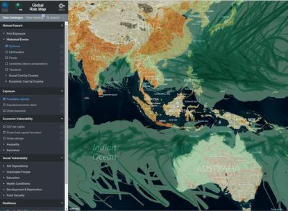
The online map allows users to overlay hundreds of datasets sourced from governments and the UN to visualise where different kinds of natural disasters have occurred with their population densities. Users can also drag and drop their own spreadsheets onto the map, and recognises latitude-longitude, postcodes and Australian Bureau of Statistics Mesh Blocks.
The software was developed by NICTA subsidiary, Terria, and is similar to NICTA's National Map released last year.
“We’ve open sourced everything that you see here under a licensing system and the software is called Terria JS,” said Peter Leihn, director of environment at NICTA.
“When you get this data out there and put it in a format that can be visualised and accessed and downloaded by people, you are actually giving the innovation community a great opportunity to analyse that data.”
NICTA is also educating governments on best practices around collecting and handling data. It has also reworked some of the datasets to meet OGC Web Services standards to build the map.
Leihn said that now it has pooled together a huge source of historical data for the map, there’s potential to do some predictive analytics on it.
“What we haven’t done at this point is getting to deeper analytics that we know that we could do with these datasets now that they are together in one place,” he said.
Murphy said there’s potential to use predictive analytics to help with hazard preparedness, but “it’s not in the scope of the project in relation to phases that we are doing now".
IAG has started work on the next phase of the project, looking at effective approaches to global outreach and stakeholder advocacy for disaster risk reduction.
“The costs of recovering from natural disasters are borne by governments, business, NGOs, donors and communities. They consume scarce public and private resources, which could otherwise be used to develop social, economic and natural capital.
“By reducing disaster risk, many losses due to natural hazards such as cyclones, floods and earthquakes can be prevented or reduced. This, in turn, will provide opportunities for more affordable, accessible and scalable insurance solutions,” she said.